The last day of our trip started with our usual early start and a light cleaning of the boat.
We found fair amount of recreational river traffic on the river owing to the holiday weekend. This slowed our progress and delayed us by about two hours when compared to a non-holiday weekday.
All in all, we have traveled around 1700 miles in 15 days, and performed 19 lock throughs.
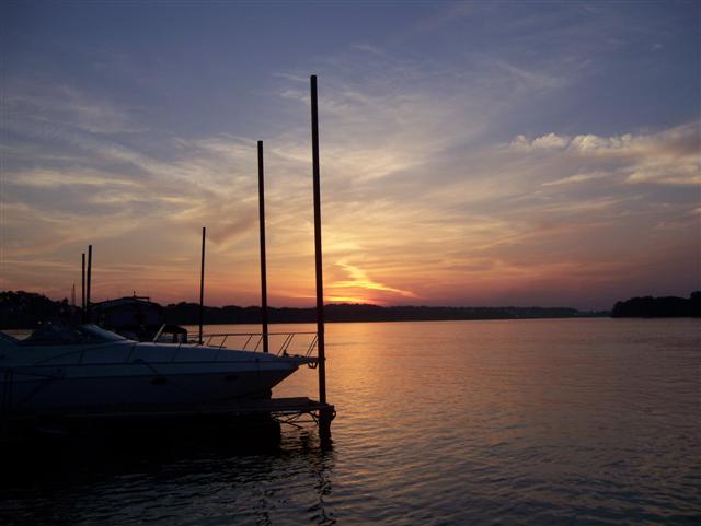
Members of The Ohio River Launch Club and family were on hand to take a line and greet us as we arrived.
Monday, May 29, 2006
The Launch Club - Island Hopper's New Home
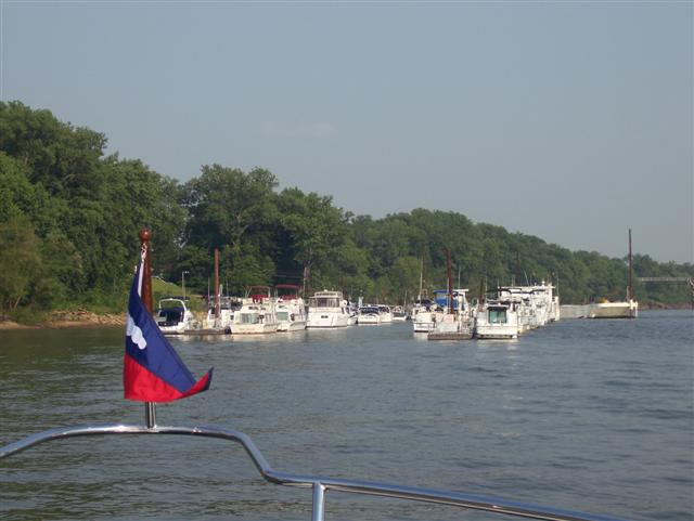
Ohio River Lanch Club, Island Hopper's new home for the next two years, than back to points South.
Saturday, May 27, 2006
Day 14 - Owensboro Kentucky to Louisville Kentucky
Another early start, need to cover 150 miles and two lock throughs to get above the dam in Louisville. Day went well, with the exception of sporadic drift, which was dense at times.
River was muddy until shortly before Louisville at which time it cleaned up to a nice blue green.
River was muddy until shortly before Louisville at which time it cleaned up to a nice blue green.

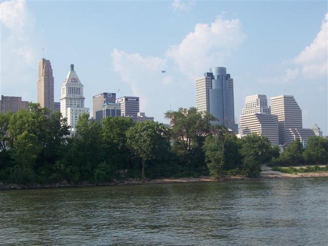
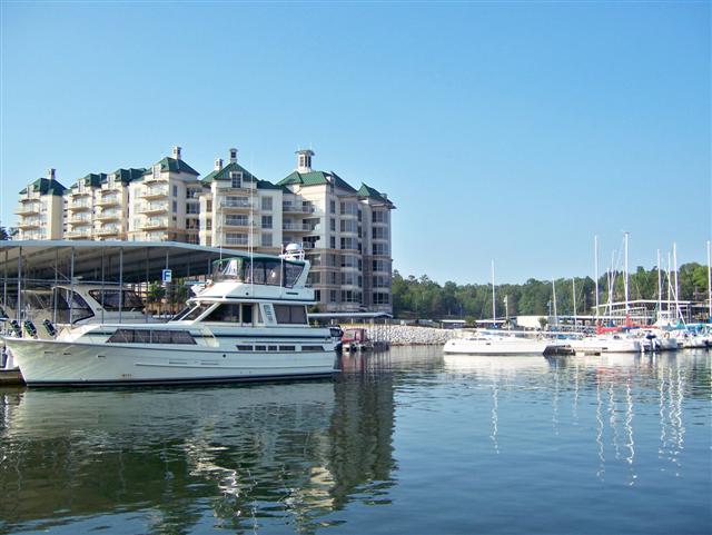
Louisville, KY

Out arrival in Louisville was pleasent in that there were no tows backed up and we were able to get through the lock with no delays.
The area below the lock is commercial, but above the lock is lake-like and had a lot of recreational boating activity.
Friday, May 26, 2006
Day 13 - Green Turtle Bay to Owensboro Kentucky
It has been a long day . . . four lock throughs and around 195 miles. It started on a bad note as the lock from Kentucky Lake was busy with a tow who was breaking his load to lock through . . . over an hour of waiting. If all locks through were to take this amount of time we would not reach our destination before dark and be forced to anchor out somewhere.
Overall we did very well, around thirteen and a half hours on the river (195 miles including 4 lock-throughs) a good dinner at the Executive Inn (docked at the Executive Marina) . . . no foul - no harm!
Overall we did very well, around thirteen and a half hours on the river (195 miles including 4 lock-throughs) a good dinner at the Executive Inn (docked at the Executive Marina) . . . no foul - no harm!

Cave–In-Rock

A place that was variously the home of pirates, counterfeiters, hi-jackers, assorted yeggs, and the haven of brave pioneers. First written about in 1924 by Rothert in “The Outlaws of Cave-In Rock” the Cave was used by Samuel Mason to provide a waylay for New Orleans flatboats to which he lured them and who were expeditiously murdered for their cargo. Now a state park, the mouth of the cave is 55 feet wide and extends back come 60 feet, it was originally partially concealed by vegetation.
Back on the Ohio

Finally, after locking through from Kentucky Lake to the Cumberland and traveling around 19 miles, back on the Ohio!
Thursday, May 25, 2006
Day 12 - Paris Landing State Park to Green Turtle Bay
Although at our our inteneded destination we have done somewhat better in terms of distance traveled per day than originally thought. In round numbers, we have traveled 1,200 statute miles with an estimated 485 statute miles to go, for a total trip of 1685 miles.
Today was a short 40 mile to get ready for a big push to Cincinnati. Laundry, groceries, a few maintenance items are all part of the preparations. Harry is calculating various options of food, moorage and dinners available on the Ohio as well as how they conicide with locks and miles to be made. Best option for tomorrow is 192 miles and three locks. We will see!
We anticipate arriving to ORLC Later on Sunday or Monday AM. This assumes the river behaves. Excessive drift (debris floating as a result of the river flooding) and or current will affect our timetable.
Tonight's dinner will be at Patti's, featuring 2" thick boneless pork chops and clay flour pot baked bread. Since this is a "dry" county, we will take our own wine (yes, it is allowed).
Maintenance Time

Island Hopper's 1,200 mile trip is turning out to be a great shake down cruise. Kevin is seen here monitoring oil levels during the engine break-in period, adjusting idle speeds and just generally making sure all is behaving!
The mechanical space looks like one could eat off the decks or bulkheads!
Day 11 - Grand Harbor Marina to Paris Landing State Park
We had a late start today, primarily due to waiting for a marine supply store to open regarding a couple of hoses. Our goal was to reach Green Turtle Bay, but we had to settle for Paris Landing State Park, a 150 mile journey instead.
Dinner was at the State Park lodge, a buffet that was both good and inexpensive. While most marinas have been providing a courtesy car, the State of Tennessee provides a ranger to drive you to the lodge. When you are finished with dinner, the front desk radios them for your pick up which is both prompt and courteous.
The trip itself started in Pickwick lake, which continued to reveal itself as a large and beautiful body of water. The two large marinas in this lake seem to attract VERY large boats from Florida for the summer, for use during that time in northern climes and now to keep the boats above the 32 degree latitude cut off for hurricanes, keeping their insurance company happy.
After descending to the Tennessee river, we made good progress to Kentucky Lake and Paris Landing State Park.
Tennessee River

After leaving Pickwick Lake, the Tennessee River provides the richness of hills and rock face as compared to the flatness of the Ten-Tom and the Tombigbee a few days ago.
Homes Around Pickwick Lake

As we traveled through Pickwick Lake, one could not but be impressed with its size, the boats on it and homes around it.

Tuesday, May 23, 2006
Day 10 - Smithville Marina to Grand Harbor Marina
We have traveled 75 miles and passed through 3 locks today. The Ten-Tom now consists of broad lakes above the dams with narrow channels below. Our first eleven lock-throughs raised us from 0 to 330 feet above sea level. The 12th of the “dirty dozen” (Whitten Lock and Dam) will raise us another 85 feet! Since the dam has no spillways, there is no flow passing through the dam except for the small amount that occurs via lock-throughs. The water below and above the dam is extremely clear.
This will be our last “up” and soon we will then we will start to go down when we cross the divide of the Tombigbee and the Tennessee watersheds (The Tennessee is north flowing while the Ten-Tom and Tombigbee is South flowing.) At this point, 150 million cubic yards had to be dug out (1,300 feet wide and 175 feet deep) in order to connect the river to these two watersheds.
Following the Tennessee watershed, we will lose elevation all the way to the Ohio at which time we will then go up again.
We are staying at Grand Harbor Marina, www.gograndharbor.com, tonight and having dinner at Johnny's Pier.

Small Upper Gates
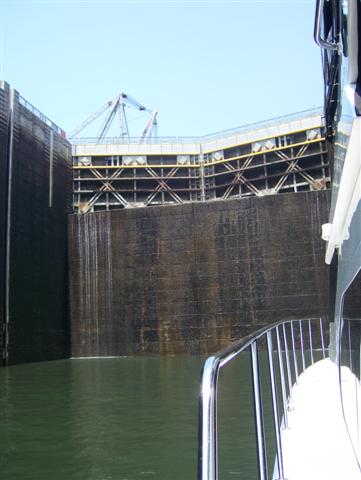
In the Whitten Lock and Dam, the majority of the upper gate is fixed, while a small portion is movable.


Monday, May 22, 2006
Updates
The updates of been sporadic as a result of no cell service or analog only cell service during our travels. We hope and expect to once again post daily in the coming days, but no guarantees.
Day 9 – Sumter Landing to Smithville Marina (Mississippi)
Left Sumter Landing at 6:55 local time for Smithville Marina, arrive at 3:30 local time. Today we passed through five locks and covered 104 miles. This is about 15 miles and three locks longer than originally planned (Aberdeen Marina).
We have been very fortunate in hitting the locks when they were not busy. The lockmasters seemed very cooperative in calling ahead to the next lock to help our passage as well. I am sure this is not possible when things are busy on the Ten-Tom.
Smithville is providing a courtesy car to go to dinner. Harry is researching the possibilities of local fare.
Towboat waiting for us to exit the lock

We have been very fortunate that we have not waited long to lock through the various locks on the Ten-Tom thus far. Hope our luck holds.
Tombigbee

The river continues to change its look as we proceed northward. Soon, it will have the appearance of a canal as we enter the engineered section.
Day 8 - Bobby’s Fish Camp to Sumter Landing
We left Bobby’s Fish camp relatively early and considered the possibility of stopping in Demopolis for fuel only and proceeding to an anchorage called Sumter Landing, a Corps of Engineers maintained camp ground and ramp. This included two locks and 150 statute miles. The entrance is extremely shallow and one must stay to the center. We showed .7 feet below our rudder, total depth around 4.7 feet at the entrance, but quickly gained depth once inside.
At mile marker 225 we officially were halfway between the Mobile and the Tennessee rivers.
Dinner was Lean Cuisine, micro-waved by Chef Hopper
At mile marker 225 we officially were halfway between the Mobile and the Tennessee rivers.
Dinner was Lean Cuisine, micro-waved by Chef Hopper


Day 7 – Dog River Marina to Bobby’s Fish Camp
We left Dog River Marina at 7:30 Central time this morning and proceeded up Mobile bay to the Mobile River. The confluence of the Tombigbee and the Alabama rivers form the Mobile River to the South.
Since the rivers had been up (high water) at times there was still some drift flowing. Additionally, since it was Saturday, a number of fisherman were out in small John Boats and Bass boats that we could easily swamp while making 19 plus miles per hours. Both required a lookout.
Had Dinner at their small Restaurant, a great Catfish Dinner, with slaw, hushpuppies and French fries. When Harry walked in, they said pick a table, Harry said I’ll sit at the one with the cute blonde.
Dinner at Bobby's Fish Camp

Dinner with Captain Frank, Terry and the owner of the boat rafted to us. Great Catfish slaw, hush puppies and fries!

Sunday, May 21, 2006


Friday, May 19, 2006
Sommelier - a necessity

Choosing ones wine can be difficult in the absence of a qualified sommelier. Harry comes highly recommended and is shown pouring a fine Chardonay.
Day 6 - Dog River Marina
Spent the day doing repairs on a few items on the boat. Re-stocked food and did laundry in anticipation for another week underway.
We will be leaving Dog River Marina in the morning, proceeding up the Tombigbee to our first stop on the river system, Bobby's Fish Camp just above the Coffeeville Lock and Dam.
We will be leaving Dog River Marina in the morning, proceeding up the Tombigbee to our first stop on the river system, Bobby's Fish Camp just above the Coffeeville Lock and Dam.
Thursday, May 18, 2006
Day 5 – Fort Walton to Mobile
Another day on the Intracoastal, which included some large bays as well as a couple of canals/rivers, as the winds were once again around 15-20 knots and from the Southwest. Today’s trip accounted for 104 nautical miles (120 Statute miles). Actually saw some barges and towboats operating on a canal next to Mobile Bay.
Our destination has been Dog River Marina where we will laying until Saturday to have some warranty items taken care of. Dog River Marina is well known to “Great Circle Captains” as the location in for repairs and other marine services (see http://www.dogrivermarina.com/) in this part of the world.
River levels on the Mobile river and the Tombigbee have been up, but by Saturday should be OK.
Salvation?

Kevin realized if he owned one of these, his hungry diesels would no longer be a concern. Last time I saw Kevin, he was on his cell trying to negotiate a purchase of an oil platform. I wonder if he can get a hose to reach Ohio?
Curacao?

Imagine our surprise to see these brightly colored houses reminiscent of Curacao. Actually on the canal (the inside) on Perdido Key.
Navigation 101

Harry, trying to determine our course for the next day . . . and more importantly, which way is North?

Wednesday, May 17, 2006

Day 4 - Panama City to Fort Walton
Short day today, covered 60 nautical miles (69 statute miles) from Panama City to Fort Walton Beach (near Destin). Took the Intracoastal water way route again since the winds were forecast to be 10-15 knots, so the seas would be somewhat rough in the gulf.
Staying at Fort Walton Yacht Club tonight and will have dinner with the club’s commodore and wife this evening. Seems Harry knows everybody.
Tomorrow we will proceed to Dog River Marina near Mobile.
Staying at Fort Walton Yacht Club tonight and will have dinner with the club’s commodore and wife this evening. Seems Harry knows everybody.
Tomorrow we will proceed to Dog River Marina near Mobile.

Tuesday, May 16, 2006
Day 3 - Carrabelle to Panama City
We decided to use the Intracoastal Waterway (ICW) rather than the Gulf, primarily due to distance. The Gulf route seemed longer while the ICW appeared to be a “cut through”.
The cannels and rivers traversed cypress swamps and pine forests. We needed to keep a sharp lookout for local fisherman as our wake was quite large when operating at 17 knots in such a narrow waterway.
The series of creeks canals and rivers dump into East Bay which connects to St. Andrew's Bay, the location of our moorage, St. Andrew's Bay Yacht Club. An interesting story here. We had reservations via Harry, and upon arrival were met at the dock by a gentlemen who said not to go back into the cut too far as it was shallow.
After a cocktail in the lounge we returned to the boat and wondered how shallow it was. After measuring the depth and realizing it was very shallow, we checked the tide tables on the GPS and came to the conclusion we would be aground by midnight. The wind was around 10 to15 knots pressing us into the dock. The only thing to do was tie the dock side stern to the dock as a pivot point , power the bow toward the channel and the wind in order to move the boat to open water. In the end several hearty “sailors” and yours truly (Ed) were able to assist in moving the bow to catch the wind to escape the dock and move the boat. We relocated to an outer dock in 15 feet of water.
Dinner tonight was in Panama City at Uncle Ernie’s Bar and Grill, an OK seafood place with a view of the bay.
Looking for Anglers

It has been pointed out that "wakeing" fisherman is a serious offense (as we all know), so extra attention, including the use of binoculars are used to loacte boats nestled among the mangroves engaged in fishing.
Searcy Creek View (ICW)

Traveling the Intracoastal (ICW) finds you at times in narrow waterways, adjoined by swamps and forests.


Monday, May 15, 2006
Day 2, Clearwater to Carrabelle, FL
A long day - probably will be the longest of the trip. We shoved off at 6:40 AM and followed our pre-programmed course to the first waypoint some 3 hour later with a second waypoint 5 ½ hours (total trip estimated at 159 plus nautical miles - 183 plus statute miles.)
During the crossing, I (Ed) was disappointed my cell phone was not working . . .taking a 2nd look at the GPS display, I realized we sepent most of the day 30 miles plus out in the Gulf . . . and not one cell tower nearby. Go figure!
Water was somewhat rough 3-4 foot waves over much of the crossing. About one third in to the 2nd leg, Harry suggested we try a more direct route and cut through a Pass rather than the more traditional Intracoastal approach to Carrabelle. Made course corrections to the GPS/autopilot on the fly, all was good.
We arrived at 4:20 PM and stayed at the Moorings. Good marina, nice lounge with pool table, wifi internet, courtesy car to take you to dinner and a local tour of the smallest police station in the country. The photo depicts my (Ed's) release from said police station after I was arrested for not eating my vegetables via a warrant initiated in Montgomery, Ohio from a family member. Extradition was waived.

Sunday, May 14, 2006
Day 1 St. Petersburg to Clearwater
Harry arrived last evening on schedule and Sharry joined us at St. Petersburg YC for dinner.
Today was a relatively short 60 mile day from St. Petersburg to Clearwater. This for all intent and purposes was a shakedown cruise to become better familiar with the auto pilot and other navigational features of the boat. Tomorrow will be a long day (over 160 miles), so we want to make sure everything is in working order.
Filled up both tanks (around 390 gallons of diesel) and settled in at Clearwater Municipal Marina. Harry and I input the next two days of courses in the GPS and Kevin did some trouble shooting on the bow thrusters, since they seem to have a low battery, even though the charger appears to be working.


Saturday, May 13, 2006
Crew

Two Crew are sharing four positions on the Island Hopper . . . Some folks wear different hats, we wear different T-Shirts
St. Pete Arrival
Ed arrived Thursday on time and cab’d to the Marina from Tampa/St. Pete airport. Kevin had arrived the night before and stayed at a local hotel since the Island Hopper was being moved to its pr-trip dock. Danny (friend and fraternity brother from college) had stopped in from Daytona and showed us some of St. Pete and Treasure Island.
Ron (Everafter marine - awsome work!) arrived early Friday to give instruction on the radar, GPS, Auto Pilot, cameras, etc. and to shakedown their operation. As in all things, a few bugs, to be remedied by a Fed Ex shipment and a return to finish his work on Saturday.
The day was busy with dinner being postponed until 7:30 due to provisioning in preparation for the trip. Our arrival on Central Ave in St. Petersburg was greeted with a parade celebrating the All States Festival (kind of a Mardi Gras theme) to kick off the National High School Band competition. A nice dinner at the Central Oyster House followed by a stop at an Ice Cream shop and fireworks next to the St. Petersburg Yacht Club rounded out the evening.
Harry will arrive this evening around 6:00 PM, completing the “crew”
Wednesday, May 10, 2006
Weather Update
In anticipation of the start of our trip am checking the weather while working in my hotel room in San Diego. Does not look good, wave forecast for Sunday at 4-6’.
Harry emails to Kevin:
“4-6 looks rough to me. Maybe what we do is take the inside up to Clearwater so we can jump off when the weather and seas permit. Your call.”
Inside vs. outside is a choice of 30 Slow Miles Inside vs. 60 Fast Miles Outside (according to Jan and Bill Haueisen in their blog at http://www.janandbillhaueisen.com/diary_25.htm). Once we get to Clearwater, may have the same wait as at St. Pete, but at least we will have moved.
I (Ed) will leave San Diego at 6:20 AM tomorrow, passing through Denver and arriving at Tampa St. Pete at 3:43 in the afternoon. Should be on board by 5:00 PM. Provisioning and shakedown scheduled for Friday and Saturday.
Saturday, April 15, 2006
The first blogged trip!
As the situation would have it, my first trip described in this blog will be aboard The Island Hopper on a trip from St. Petersburg Forida to Green Turtle Bay at Kentucky Lake. This trip should start the middle of May and is via the Gulf of Mexico to the Tombigbee River, to the Tenn-Tom Waterway, to the Tenessee River and finally to Kentucky Lake, lasting two weeks.

Subscribe to:
Posts (Atom)